Some caravan and motorhome campsites are in remote locations, often with narrow lanes to negotiate or one wrong turn and it’s a major detour!
Luckily, when making your booking many site owners will give you detailed instructions so reaching your holiday destination is as stress-free as possible.
In our recent poll we asked caravan and motorhome owners to vote for their top wayfinding accessory to get to their chosen campsite.
With four main options to choose from there was one stand-out winner in what one of our most popular polls this season.
The results…
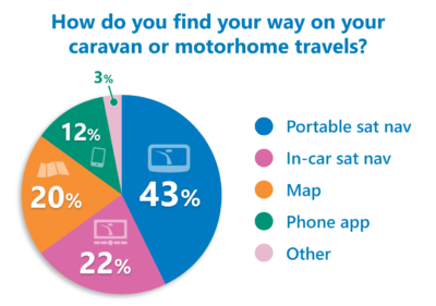
After totting up almost 600 votes, topping the polls in first place was a portable sat nav with 43 per cent of the votes – some even commented that a sat nav had saved their marriage! There were also lots of readers who used a sat nav in conjunction with a map to double check they’re on the right track.

In second place was an in-car sat nav with 22 per cent of the votes. But it was followed closely by a good old fashioned map with a fifth of the votes (20 per cent) – again some using Google Earth street view too to check the road accessibility before they set off.
Just 12 per cent of voters said they used a phone App, with a variety of different Apps mentioned.
Due to the popularity of sat navs we take a look at three star players in recent gear guide on caravan and motorhome journey planning tools.
Your comments…
Many readers rely on a multitude of tech and paper to plan their caravan and motorhome travels.
George Wade said he uses a good, old fashioned, map plus Google Earth street view to have a look at the type of roads. “That way I know what’s coming and can change route if necessary,” he said “Never had a problem.”
Clare also uses a road map, Google maps and directions from the campsite with her pre-journey planning and Rob was similar: “I use a map initially, plus maybe Google street view if unsure of access, then Tom Tom sat nav on route,” he said. “Works for me.”
Stephen Wills said: “I ultimately use a sat nav. The route always has influence from the site directory and checked on Google maps before pinpointing the approach to the campsite with via points on the sat nav.”
Caravanner Walkingbry uses a Garmin sat nav with a caravan setting and sites already installed: “Works so well – we often leave it in caravan mode to avoid narrow lanes with no turning points and damaging brambles,” he added.
Motorhomer Joh Baughan said his motorhome has an in-built satnav which uses “lorry” settings and knows the size of the vehicle to make sure they don’t end up stuck in narrow lanes. “We always have a map book and the site instruction as well, because most site instruction tell you which routes to avoid.”
But John Burrell likes to use a map, his memory and the campsite’s instructions to get to the last couple of miles of his destination.
Mike Pearn uses a phone app called Navigator and states he’s driving a truck. “Works brilliantly,” he commented.
Over to you…
What do you make of the results? Feel free to add you comments below.


We use CoPilot app on a tablet and have it mounted on our dashboard of our Bessacarr Motorhome. You can set up your profile with your vehicle dimensions so that in theory it doesn’t take you down any road where you can fit or turnaround. It clear and easy to use and so far we have used it for trips to the Lakes, touring Scotland and touring Wales and its been spot on. As a back up we always use a map and have the Camping & Caravan Navigation Atlas. The only negative in having it on a tablet with no wifi is we don’t have traffic updates which you could upgrade to if it was on a smart phone, we just use another app for that.
Having just spent 4 weeks in Brittany using only the “Aires-France” book. They give the campsite locations in Latitude and Longitude (eg N48*39.307′ W002*19.939′). It is extremely accurate, especially as the last figure is a thousands of a minute which is equal to 2 yards. Had to use the “Coordinates” setting to enter the Lat and Long on my portable car sat nav. More accurate than postcodes!
We where on holiday in Dorset last year, using a Tomtom 6200 with built in phone chip, The route put us on around 15 miles of single track road , absolute nightmare. On return I purchased a Tomtom 6200 lorry satnav. This was set up for forty foot long seven and half foot wide and nine foot high vehicle. This satnav is also equipped with phone chip and wifi, and was updated minutes before leaving on a trip to Jaywick from Tamworth. The Satnavs map was not up to date with the roadworks around Cambridge on the A14, and believe it or not managed to put us on single track road for about 5 miles before we got to our destination.