As we hit the road in our caravan and motorhomes after lockdown we find out how much drivers rely on technology to get to their holiday destination.
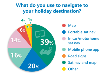
In our recent poll we asked how motorists navigated to their chosen campsite when towing their caravan or driving a campervan or motorhome? The results reveal that a massive 89 per cent of owners use technology, by way of sat nav or mobile phone app.
How caravanners and motorhomers find their way

More than a third of voters (39 per cent) admitted combining using a sat nav and map to find their way and a fifth said they used a portable sat nav, adding that bespoke units allowed them to put in their caravan or motorhome dimensions to avoid being taken down unsuitable roads.
There are a multitude of mobile phone apps which can be used as sat navs and many include live traffic updates to warn drivers of delays. Sixteen per cent of voters said they used a mobile phone app when travelling to a campsite.
As we come to rely on technology, many cars and motorhomes come with a sat nav built into the dash board and 14 per cent said they used these for wayfinding.
A small six per cent of caravanners and motorhomers used a map and only one per cent simply followed the road signs.
Your comments
Many motorists seem to have a lack of trust in their sat nav and combine technology with a map or by planning their route before they set off.
Peter Roberts told us he uses the in car sat nav as a back up and follows the route he’s planned and written down beforehand.
“Sat nav usually catches me up and does the redirection,” he said. “I admit to being old school and love a map, but a mix of modern technology keeps me out of trouble, I also have the time to do it. Not the first time I have used the old fashioned road map to get out of a tailback of traffic.”
John Vicca doesn’t leave anything to chance and uses a combination of a pre-journey map recce, windscreen mounted sat nav and CoPilot Truck Navigation App on his phone.
“To be honest the phone app is best as can set for vehicle dimensions whereas the sat nav has a tendency to select narrow lanes,” he commented.
Similarly, Paul Upshaw makes sure he has his journey well planned.
“I use a road map to plan for the majority of the route and then I use Google mapping to get an idea of road features for the last few miles, setting up our sat nav system and written instructions for the last few miles, as normally when you get close to the sites there can be a lot of potential hazards down country lanes. Also, I normally phone the site for an approach route a few days before setting off.”
Annie Dobbie uses a Garmin sat nav that allows you to input the size of the motorhome. “At times I find the route calculated goes a bit off course, to help ensure that doesn’t happen too often, we plot the route in Google maps (this usually gives accurate real time traffice conditions), and at times the route maps we carry.”
Over to you…
What do you make of the sat nav results? Let us know in the comments box below.


We bought an aguri motorhome sat nav and dvr inc internet love it not let us down all the apps are brilliant to a motorhome user also can be used for a car
Interesting stats. Which apps do people recommend to download – those that can be tailored to suit dimensions?
I use a Snooper Ventura Caravan And Motorhome Version with the camping sites already loaded, my main reason is I can program when I am using my tow car settings for length and also height so that it doesn’t take me towards low bridges and difficult turns. I have recently done the
North Coast 500 (NC500) without any hitches. Maybe not the cheapest but certainly works for me.
Really useful, more please